Au Sable River
From Mio Pond to Lake Huron, the Au Sable is primarily managed by the HMNF. The river is managed in two sections, one from Mio Pond to Alcona Dam Pond, the second from Alcona Dam to Lake Huron.
Au Sable National Wild and Scenic River
The Au Sable National Scenic River stretches 23-miles, from Mio to Alcona Pond.
Au Sable River - Alcona Dam to Lake Huron
This section provides motorboat opportunities with a lake fishing atmosphere.
Highbanks River Trail
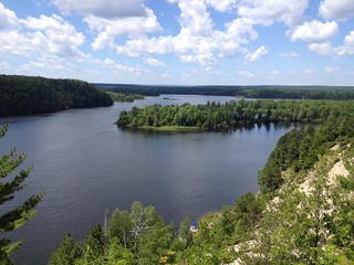
A short, 7-mile hike along the bluffs of the Au Sable River will provide day hikers with some of the best, and most dramatic, views of the Au Sable River, where hikers or skiers will be able to look over the river valley, with clear views almost to Lake Huron in some spots.
Lubmerman's Monument Visitor Center and Forest Discovery Trial
Lumberman’s Monument Visitor Center interprets the area’s colorful lumbering past. The 14-foot Lumberman’s Monument stands on a high bank with the Au Sable River providing a scenic backdrop.
River Road National Scenic Byway
The twenty-two mile River Road National Scenic Byway extends westward from Lake Huron into the Huron National Forest. It parallels the historic Riviere aux Sable (River of Sand). Lumbermen’s Monument Visitor Center sits at the center of the byway.
Brochures and Maps:
- Au Sable National Scenic River (pdf)
- River Road National Scenic Byway (pdf) - this brochure shows River Road, the Au Sable River and Lumberman's Monument
- Highbanks River Trail Map (coming soon)
- Eagle Run Trail Map (coming soon)
Flickr Photo Albums:
Activities
- Interpretive Programs
- Auto Touring
- Biking
- Boating
- Camping
- Fishing
- Hiking
- Picnicking
- Recreational Vehicles
- Visitor Center
- Wildlife Viewing
- Swimming

